
Putting a Nation on the Map: The Construction of a Geographical Imaginary through the Project for a National Atlas of Ethiopia, 1962–1987
- Publication
- Comparativ
- Volume
- 32
- Issue
- 2
- Pages
- 264-288
Ethiopia
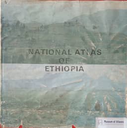
1981–1988Marie Huber examines the 1981 preliminary and final National Atlas of Ethiopia within the history of state cartography and nation-building. The article generally dates the final edition to 1987, while the linked publication is dated 1988. The 1981 edition contained 90 black-and-white maps, sold out its print run of 600, and explicitly acknowledged the provisional character of its data. More than twenty maps addressed population and social conditions, including birth and death rates, household size, health and education. The final edition contained 75 colour thematic maps and was completed with Canadian International Development Research Centre assistance. Huber highlights its greater reliance on Ethiopian institutional data and census results, its more differentiated treatment of language distribution, and its extensive depiction of state enterprises, collectivized agriculture and infrastructure planning. Huber interprets these maps as instruments of a state-sponsored Greater Ethiopian identity. She argues that territorial classifications supported bureaucratic control, while the final edition’s eleven historical maps presented a continuous national history. Her examples include portraying nineteenth-century southern conquests as reunification and omitting conflicts over Eritrea, Somalia and Ogaden from a map of postcolonial neighbours. She also traces a shift towards locating Ethiopia within Africa. The article leaves the atlas’s actual reception and its use in planning and education as questions for further investigation.
View whole-article summary
Marie Huber traces Ethiopia’s national atlas project from A Preliminary Atlas of Ethiopia (1962), through a 1970 revision and the 1981 Preliminary Edition, to the official National Atlas of Ethiopia, generally dated 1987 in the article. Her analysis uses the 1962, 1981 and final editions alongside geographic publications; the 1970 revision was unavailable. She connects atlas compilation to the state mapping institute founded in 1954, US-assisted training, geodetic surveying and aerial photography, subsequent UN support, and Canadian assistance for completing the official atlas. The publications expanded from 34 black-and-white maps in 1962 to 90 in 1981 and 75 colour thematic maps in the final atlas. Compilation shifted from foreign sources, theoretical extrapolation and limited surveys towards data supplied by Ethiopian institutions, including the population surveys begun in 1984. Huber examines increasingly differentiated language maps, expanded social and economic mapping, and historical maps that presented territorial conquest as reunification and omitted conflicts threatening national unity. She interprets these classifications and historical narratives as instruments of spatial appropriation and the construction of a Greater Ethiopian identity under both imperial and socialist governments. Maps positioning Ethiopia internationally also register a shift from Western and UN connections towards an African regional orientation. Huber treats the atlases as sources for contested unity policies and ethnic conflicts, while identifying reception, classroom use and practical applications in planning as subjects requiring further research.
Related Atlases
Comments
Loading...
0/2000