
National and regional atlases: Turkey
Atlas nationaux et régionaux : la Turquie
- Publication
- Méditerranée
- Volume
- 70
- Pages
- 75-76
Türkiye · Version 1
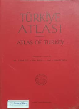
1961M. Bazin describes the 1961 Atlas of Turkey, published by Istanbul geographers, as comparable in conception to the Atlas de France. Apart from a one-page preface, it presents maps and diagrams without commentary, arranged in nine sections covering physical geography, population, economic activities, communications and administrative divisions. Climate receives the most extensive treatment, with 43 maps and inset maps; topographic coverage includes eight sheets at 1:800,000. Bazin argues that the delay between completion of the maps in 1954 and publication in 1961 left its human and economic geography outdated on arrival: population distribution relied on the 1935 census, other demographic maps on the 1950 census, and agricultural and livestock data on averages for 1950–1952 and 1945–1950 respectively. He adds that demographic and economic changes accelerated this obsolescence, while advances in geological surveying and plate tectonics soon dated some physical maps as well.
View whole-article summary
This article reviews the development of national and regional atlases in Turkey. The tradition began in the 1930s with Faik Sabri Duran's Grand World Atlas, but the 1961 Atlas of Turkey, though ambitious, was quickly outdated due to obsolete data (e.g., population based on the 1935 census). The 1977 New Atlas of Turkey, published by the military, disappointed scholars due to limited thematic coverage, uneven content, and factual errors. Subsequently, Turkish geographers turned to scattered high-quality publications, such as maps in the Tübingen Atlas of the Middle East. The article concludes that Turkey's administrative structure, lacking intermediate levels, hinders regional atlas production, making regional synthesis manuals a more likely path forward.
Related Atlases

Comments
Loading...
0/2000