
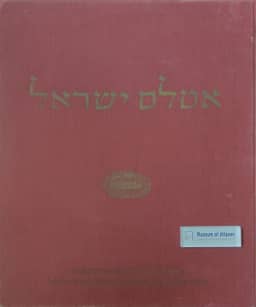
The atlas of Israel
L'atlas d'Israël
- Publication
- Annales de Géographie
- Volume
- 369
- Pages
- 442-444
Israel · Version 1
1956–1970André Libault reviews the first four fascicles received of the Atlas of Israel, presented as Israel’s national atlas, whose publication began a year earlier. Directed by a team drawn from geographical, surveying, meteorological and publishing institutions, it is planned to contain about one hundred sheets in fifteen sections, with particular weight given to history and cartographic representations of the territory. Libault praises its large format, folding sheets and scales adapted to each subject, which support detailed comparisons of current conditions and historical change. He discusses reproductions of old maps, physiographic classification and terrain profiles, combined drainage and rainfall mapping, and animal-distribution maps extending beyond national borders. Other examples include vegetation landscapes reconstructed for the early nineteenth century and 1870, population change from 1922 to 1953, settlement types classified by topographic site, and retrospective maps of agriculture, industry, commerce and transport. He reserves judgment on the landscape study until further sheets appear. Libault emphasizes the atlas’s sustained connection between the present and the past and praises its printing, while finding some colours too pale for clear symbols. Hebrew notices and the lack of a complete translation restrict his assessment and international access; an English-text volume is planned after completion of the Hebrew publication.
Related Atlases
Comments
Loading...
0/2000