
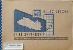
Atlas and maps. Census atlas of El Salvador.
Атласы и карты. Цензовый атлас Сальвадора
- Publication
- Реферативный журнал. География
- Issue
- 4
- Pages
- 16
El Salvador
1955This Russian notice, citing a Hungarian review by András Vagács, describes the Census Atlas of El Salvador (San Salvador, 1955). Compiled by the economic, cartographic and geographic divisions of the national statistical administration, it contains 79 maps and numerous graphs, photographs and drawings presenting the country’s geography and economy. Instructions for using the maps precede a geographical and historical account of continental Central America illustrated with five maps. The El Salvador sections cover physical conditions, population based on the 1950 census, school locations, agricultural land use, crops, livestock, sugar factories and electrification. Text, statistical tables and graphs explain and supplement the maps. The atlas concludes with descriptions of administrative regions and schematic plans of their centers identifying public buildings and industrial establishments, followed by an index of geographical names.
Comments
Loading...
0/2000