
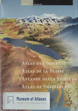
Atlas of Switzerland 2 - A highly interactive thematic national atlas
- Publication
- Multimedia Cartography
- Pages
- 161-182
Switzerland · Version 2
2000–2010René Sieber and Stefan Huber describe the concepts, production, implementation, and functions of Atlas of Switzerland 2, the 2004 second interactive edition published on CD-ROM and DVD in German, French, Italian, and English. Building on the 2000 edition, it underwent a fundamental graphical and technical redesign. Its user-centered “GIS in Multimedia” approach combines custom-built navigation and analytical tools with cartographically refined data. The authors’ “Adaptive Map” concept uses multiscale layers, controlled symbol enlargement, predefined settings, and interactive adjustments to maintain legibility during exploration. A map-dominated, modular interface provides consistent access to thematic navigation, spatial navigation, visualization, analysis, and export. The article details the collaborative production process. ETH Zurich coordinates development and editorial work; swisstopo contributes cartography, multimedia, manufacturing, marketing, and distribution; and the Swiss Federal Statistical Office supplies statistical data and translations. More than 50 data owners and over 20 professional translators contribute. Editorial work proceeds from investigating topics and sources to checking, harmonizing, completing, recoding, and cartographically refining data, then implementing topics through XML map descriptions and integrating multimedia. Consultation with data owners and experts accompanies production. Editorial and technical prototyping took more than two years, with iterative functional and usability testing. The software separates interface, core, and data, combining Macromedia Director and Lingo with extensive C++ components. AoS2 contains more than 1,000 topics and 7,000 maps, including over 650 nature and environment topics and over 350 statistical topics. Its 2D tools support querying, classification, comparison, overlays, temporal exploration, and export, supplemented by explanatory texts and other media. The 3D section combines panoramas and block diagrams with ray-traced terrain, analytical and thematic overlays, terrain profiles, and extensive queries. Navigation includes continuous movement, camera and line-of-sight controls, a summit-based “climber” mode, and nearly 7,000 predefined viewpoints. The authors characterize the edition as mature and extensible. They outline planned transportation and energy themes, followed by culture and history, alongside additional visualization and GIS tools and possible Internet, school, regional, and tourism products.
Related Atlases
Comments
Loading...
0/2000