
Dominican Republic
National Atlases
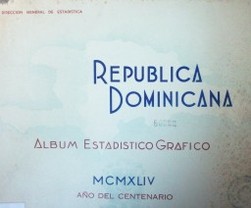
The national atlas tradition of the Dominican Republic emerged in the mid-20th century, shaped by the country's drive toward statistical modernization and development planning. The earliest work in this collection, the 1944 graphic-statistical album, was produced by the Dirección General de Estadística y Censos, reflecting a post-Trujillo-era emphasis on quantifying national resources and population. This album, published in both English and Spanish, combined statistical charts and maps to present a visual profile of the nation. The second atlas, from 1966, marks a shift toward integrated development planning, as its title indicates—it inventories basic existing information and outlines guidelines for comprehensive national development. This work reflects the influence of international planning methodologies and the post-1965 political transition. Together, these two atlases illustrate a transition from descriptive statistical compilations to prescriptive planning tools. While modest in number, they laid a foundation for later cartographic efforts in the country, establishing a tradition of using maps and data as instruments for state-building and socioeconomic policy. Their bilingual nature also signals an early engagement with international audiences and technical cooperation.
Versions and Their Documents
Contemporary and Later Comment
- Journal Article1957National atlases: a summary
Ena L. Yonge
This article provides a comprehensive review of national atlases published worldwide up to the time of writing. It notes that since the Geographical Review first coined the term 'Age of National Atlases' in 1940, the surge of nationalism after World War II has greatly accelerated the production and scope of such atlases. The author surveys 26 published national atlases and 3 in preparation. The article first emphasizes that a national atlas aims to portray all aspects of a country—physical, economic, and social—and highlights a welcome trend: the inclusion of map titles, legends, and text summaries in English or French for atlases published in less familiar languages. The review is then organized by region. For Europe, it details atlases from Austria (Atlas von Niederösterreich), Belgium (Atlas de Belgique), France (revised Atlas de France), and Germany (Deutscher Planungsatlas, specifically Atlas von Berlin), among others, discussing their institutional backing, content structure, scales, cartographic techniques, and unique features, such as Berlin's depiction of wartime damage and postwar development, and Belgium's detailed demographic and agricultural maps. Atlases from Czechoslovakia, Denmark, Finland, Italy, and Norway are also mentioned. For Africa, the planned Atlas du Maroc is described. For Oceania, the Atlas of Australian Resources is reviewed, highlighting its origin in post-war resource assessment, its effective use of a large scale, and its focus on water resources and population distribution. For North America, the article reports on the progress of a Canadian national atlas and the initiation of the National Atlas of the United States, a collaborative federal effort to compile standardized thematic maps from various government agencies. The article concludes that these national atlases represent significant achievements in geographic and cartographic scholarship, serving as invaluable resources for students, planners, and businesses.
- Journal Article1972Atlases of the western hemisphere: A summary survey
Richard W. Stephenson
This article reviews significant atlases published in the Western Hemisphere (including North America, South America, and Central America and the Caribbean) since Ena L. Yonge's summary survey in 1962. The survey is divided into two parts, with this part focusing on the Western Hemisphere, covering 147 volumes of general and thematic atlases of the entire hemisphere, continents, major regions, and individual countries, as well as atlases of individual states and provinces of the United States and Canada. Notable atlases mentioned include the 'Alpha Map Transparencies' series for teaching regional geography, Theodore R. Miller's 'Graphic History of the Americas,' David K. Adams and H. B. Rodgers' 'An Atlas of North American Affairs,' and the 'Oxford Regional Economic Atlas: United States & Canada.' The Canadian section details the fourth edition of 'The National Atlas of Canada,' the 'Atlas and Gazetteer of Canada,' historical atlases, and the 'Atlas of Alberta.' The South American section covers atlases from Argentina, Brazil, Chile, Ecuador, Peru, Surinam, and Venezuela, such as the 'Atlas nacional do Brasil,' 'Atlas histórico geográfico y de paisajes peruanos,' and 'Atlas de Venezuela.' The article aims to describe the contents and features of these atlases rather than provide critical evaluations, and concludes by suggesting that the next decade may see an increase in the production of high-quality atlases by Western Hemisphere nations.
From the Physical Collection
Photographs are being prepared for this hall.